


Coming soon
04:21
Learn
Field surveying, taught well.
Plain-language tutorials, deep guides and a working glossary, for the surveyors, engineers, farmers and students learning MapLab Survey.
Mercator neleri doğru göstermiyor, sen neleri bilmiyordun?
Earth Shift, harita projeksiyonlarının dünya algımızı nasıl çarpıttığını canlı keşfettiğin bir araç. Ülkeleri sürükle, boyutları karşılaştır, paylaş.
Quick start
Your first survey in 60 seconds.
Three taps from install to a measured polygon you can email to a colleague.
-
01
Open & locate yourself
Tap the locate button. The map snaps to your GPS position, typical phone accuracy is 3–5 m.
-
02
Draw your polygon
Tap Add, then tap once at every corner. Auto-snap (5 m) keeps your last vertex tidy.
-
03
Read area & export
Open the feature sheet to see area, perimeter and coordinates. Hit Share to send KML, DXF or PDF.
Tutorials
Pick a topic.
Nine guided walkthroughs covering the workflows our customers ask about most.
01 / 09
Drawing & measuring basics
Points, lines and polygons, and how to read what they tell you.
Read tutorial 02 / 09Coordinate systems explained
TUREF, UTM, ITRF, EPSG codes, what to use, when and why.
Read tutorial 03 / 09Stake-out in the field
Aplikasyon adımları: koordinata yürü, açıyı doğrula, kazığı çak.
Read tutorial 04 / 09Cut & fill volumes
SRTM DEM altında kazı-dolgu hesabı. Şantiye planlaması için pratik bir adım adım.
Read tutorial 05 / 09Elevation profile & contours
SRTM DEM'den eş yükselti eğrileri ve eğim profilleri çıkarmak.
Read tutorial 06 / 09Importing cadastre KMLs
Tapu / kadastro parsellerini KML olarak içe aktarıp arazide çakıştırmak.
Read tutorial 07 / 09Connecting RTK / GNSS
Harici RTK alıcılarını NMEA üzerinden bağlayıp santimetre hassasiyetine ulaşmak.
Read tutorial 08 / 09Exporting to CAD & GIS
NetCAD, QGIS ve ArcGIS için DXF, KML, GeoJSON çıktıları, kaybetmeden çift yön.
Read tutorial 09 / 09Professional PDF & Excel reports
Saha ölçümlerinden hızlıca teslim edilebilir raporlar üretmek.
Read tutorialFeatured tutorial · 8 min read
Measuring a parcel with TUREF, exporting to NetCAD.
A real workflow, Yenimahalle, Ankara. From the App Store icon to a clean DXF on a draftsman's desk.
39.9334° N · 32.8597° E · TUREF / TM30 (EPSG:5254)
-
01
Find the parcel on satellite imagery
Open MapLab Survey, switch the basemap to Hybrid, and pan to the parcel. Imagery is sub-meter in most Turkish cities, good enough to recognise individual trees and fence lines.
-
02
Switch the coordinate system to TUREF
Open the map type sheet and tap Coordinate system → TUREF / TM30 (EPSG:5254). Every coordinate you read from now on is in metres, matching the cadastre.
Tip: Use TM30 for Ankara, TM33 for Istanbul, TM36 for the eastern provinces. Wrong central meridian = systematic eastings shift.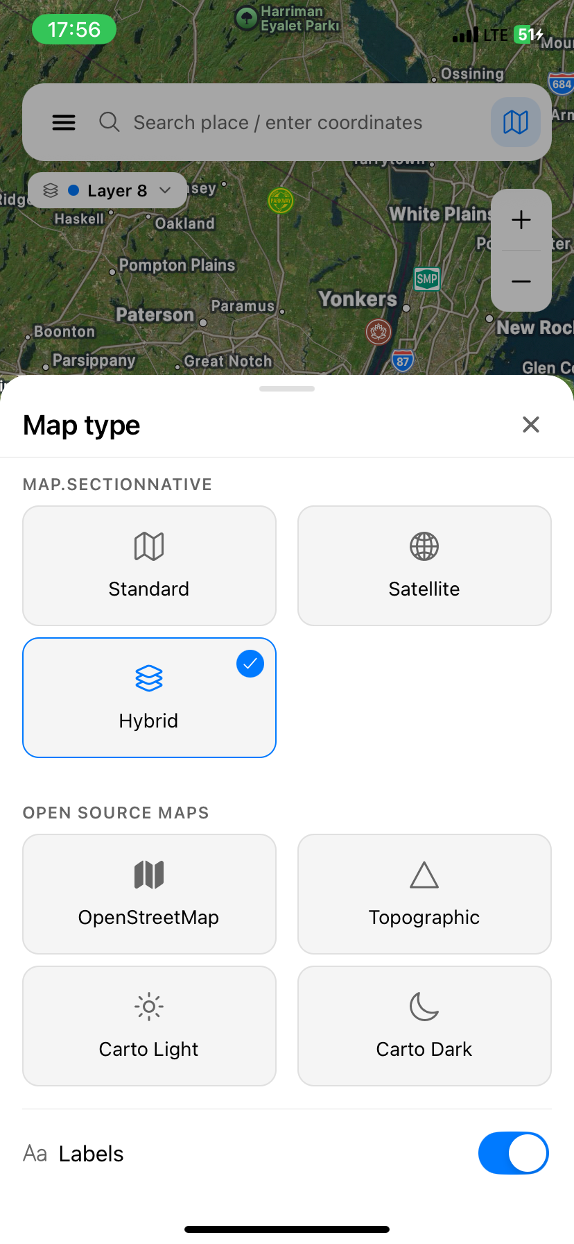
-
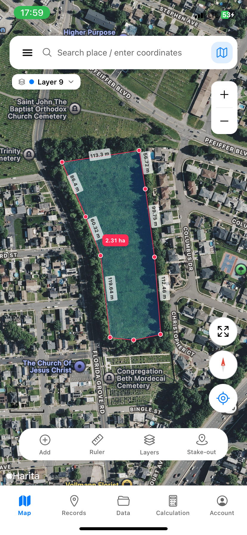
03
Drop a vertex at every corner
Tap Add → Polygon. Walk the boundary if you can, tapping the screen at every corner. Snap (yakalama) automatically pulls your last vertex onto the previous edge when you close.
Warning: Phone GPS alone gives 3–5 m accuracy. For cadastral work pair an external RTK receiver (see tutorial 07). -
04
Read area, perimeter, edge lengths
The area pill in the centre updates live. Edge labels show metric distances. For this parcel: 2.31 ha · perimeter 588 m. Six edges, each labelled.
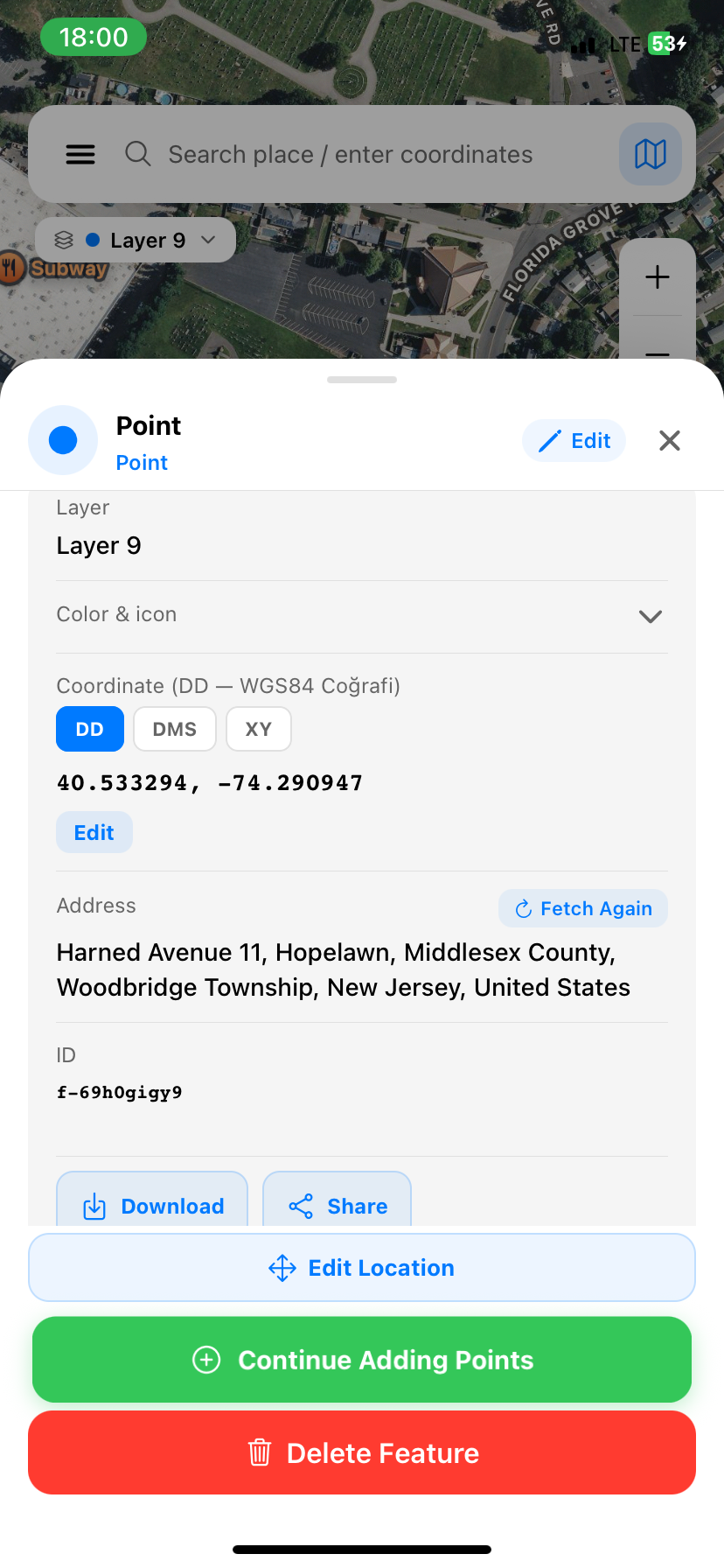
-
05
Inspect each corner point
Tap any vertex to open its feature sheet. Switch between DD (decimal degrees), DMS and XY (TUREF metres), the same point, three formats. The reverse-geocoded address is included automatically.
Tip: The feature ID (e.g. f-69h0gigy9) is permanent, useful when sharing a specific corner with a colleague. -
06
Export DXF for NetCAD
From the feature sheet, tap Share → DXF. The export uses TUREF metres directly, drag it into NetCAD and your parcel sits on top of the cadastral layer without a single transform.
Also exports: KML / KMZ for Google Earth, GeoJSON for QGIS or ArcGIS, CSV for spreadsheets, PDF for the file.
Video · Coming soon
Watch a real survey, end to end.
We're filming three short walkthroughs with working surveyors. Expected this autumn.
Coming soon
06:08
RTK setup with a Bluetooth GNSS receiver
Coming soon
03:42
Cut & fill: from SRTM to a site estimate
In-app tour
28 steps inside the app.
Every new install ships with a 28-step interactive tour. Menu -> Tutorial -> Field Tour, to replay it anytime.
- Welcome
- Menu & account
- Search & coordinates
- Map types
- Add a point
- Draw a line
- Draw an area
- Ruler modes
- Layers
- Stake-out
- AR compass
- Quick menu
- GPS track
- Contour lines
- Cut & fill volume
- Elevation profile
- Buffer zones
- Import / export
- Offline maps
- Reports
- Settings
- Profile
- Cloud backup
- Pro subscription
- Feedback
- Help
- Farewell
- Finish
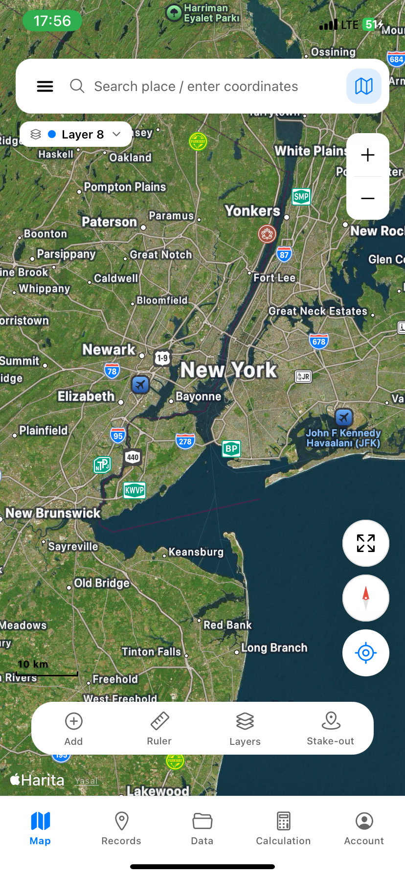
Basemaps
Eight maps to choose from.
Each basemap is best for a different kind of work. All of them cache offline (except Apple Standard on iOS).
| Type | Best for | Offline cache |
|---|---|---|
| Satellite (ESRI World Imagery) | Parcel ID, land cover, sub-meter detail | Yes |
| Hybrid (default) | Satellite + road and place labels | Yes |
| OpenStreetMap | Streets, buildings, addresses | Yes |
| ESRI Topo | Topography & relief shading | Yes |
| OpenTopoMap | Contour-style topographic map | Yes |
| Carto Light / Dark | Clean background for analysis & print | Yes |
| ESRI Wayback (historical) | Past satellite imagery (2014, 2017, 2020, 2023) | Yes |
| Apple Standard (iOS) | Apple Maps native style | No (Apple license) |
Field tips
Six habits that make every survey easier.
Small adjustments to how you carry the phone, set up the day, and structure your project, collected from real field use.
01
Work in the open
Step away from buildings, foliage and steep walls. Open sky = healthy GPS signal. Wait 3–5 seconds after starting the app for the first fix to stabilise.
02
Cache the area the night before
Download offline tiles for tomorrow's site over Wi-Fi the evening before. Saves data, saves time, and works when the cellular signal disappears at the bottom of a valley.
03
Color-code layers by type
Blue for water, green for agriculture, red for structures. When you reopen the project six months later, you'll thank yourself.
04
Hold the phone flat
The compass calibrates better when the phone is horizontal. For AR stake-out and bearing readouts, keep it level.
05
Attach a photo to every important point
A picture beats a paragraph of notes. Photos are geotagged automatically, and they survive the round-trip to KML / KMZ, so colleagues see exactly what you saw.
06
Switch CRS to match the cadastre
For parcels in Ankara, set TUREF / TM30. Istanbul → TM33. Eastern provinces → TM36. Wrong central meridian gives a systematic eastings shift you'll spot only after the report is printed.
Glossary
A working surveyor's vocabulary.
Twenty terms you'll meet inside the app, with plain definitions.
- CRS · Coordinate Reference System
- The combined recipe of an ellipsoid, datum and projection used to place a coordinate on the ground.
- EPSG code
- A four- or five-digit ID for a specific CRS. TUREF / TM30 is EPSG:5254; WGS84 is EPSG:4326.
- WGS84
- The global datum used by GPS. Latitude / longitude in degrees. The default in MapLab Survey.
- UTM
- Universal Transverse Mercator. Splits the world into 60 six-degree zones; coordinates are eastings and northings in metres.
- TUREF
- The official Turkish national datum since 2005. Three TM projections (TM30, TM33, TM36) split the country.
- ITRF
- International Terrestrial Reference Frame. The geocentric realisation behind WGS84 and TUREF, refined every few years.
- ED50
- European Datum 1950, Türkiye's pre-TUREF system. Still appears on older cadastral plans.
- ETRS89
- The European terrestrial reference. Used by neighbouring countries; useful for cross-border projects.
- DEM · Digital Elevation Model
- A raster grid of elevations. Inputs for contour lines, slope analysis and cut & fill volume.
- SRTM
- NASA's Shuttle Radar Topography Mission, a free global DEM at 30 m resolution. The default elevation source in Survey.
- NMEA
- The standard text protocol GNSS receivers stream over Bluetooth or serial. Survey reads NMEA over Bluetooth Classic and Serial.
- RTK
- Real-Time Kinematic. A correction technique that pushes raw GNSS error down from metres to centimetres.
- NTRIP
- The protocol that delivers RTK corrections over the internet. Connect to a CORS network and your receiver gets cm-grade fixes.
- GNSS
- Global Navigation Satellite System, the umbrella for GPS (US), GLONASS, Galileo and BeiDou.
- Geoid
- The bumpy surface that approximates mean sea level. Heights matter: ellipsoidal vs. orthometric can differ by 30–50 m.
- Stake-out
- Walking from your current GPS position to a target coordinate. Survey shows live distance + heading.
- Buffer
- An offset polygon around a feature at a fixed distance. Used for setbacks, easements, riparian zones.
- Cut & fill
- The volume of earth to remove (cut) or import (fill) to bring terrain to a target elevation. Computed under a polygon from the DEM.
- Contour line
- A line on the map joining points of equal elevation. Tight spacing = steep slope.
- Bearing · Azimut
- A direction measured clockwise from north, 0°–360°. Survey shows azimuth on every line and edge.
- Snap
- Magnetic alignment of a vertex to a nearby line, point or grid intersection. Default radius 5 m.
FAQ · For new users
First-day questions, answered.
Which app do I download first?
Start with MapLab Survey on the App Store, it's the only live app today, and it covers measurement, stake-out and export end-to-end.
Do I need internet to use it?
No. Cache map tiles for your area first; everything else, drawing, measurement, coordinate conversion, export, works fully offline.
Why are my coordinates different from the cadastre?
Almost always a CRS mismatch. Your phone reports WGS84 lat/lon; the cadastre uses TUREF / TM30 in metres. Switch the display CRS in Survey and the numbers line up.
How accurate is my phone's GPS?
Typical phone GPS gives 3–5 m horizontal under open sky, worse near tall buildings. For cm-grade work, pair an external RTK receiver over Bluetooth.
Can I share a project with a colleague?
Yes. Export the layer as KML or KMZ and email it. They can import it directly into MapLab Survey, Google Earth, QGIS or NetCAD.
Does it work on Android?
Not yet. iOS is live today; Android is on our roadmap. Sign up via the contact form on the home page and we'll email you at launch.
Is it really free?
Yes, every feature, every coordinate system, every export format. No tiers, no in-app purchases.
Support
Stuck on a real survey?
Email us. We answer surveyors directly, usually within a day. If you're hitting an edge case the docs don't cover, we want to know.
maplabtech@gmail.comEarth Shift
Mercator neleri doğru göstermiyor, sen neleri bilmiyordun?
Earth Shift, harita projeksiyonlarının dünya algımızı nasıl çarpıttığını canlı keşfettiğin bir araç. Ülkeleri sürükle, boyutları karşılaştır, paylaş.
Aracı dene01 Nasıl çalışır
Üç adımda projeksiyon yanılgısını canlı gör
01
Bir ülke seç
Hızlı listeden, sıralamadan veya aramadan herhangi bir ülkeye tıkla. Renkli polygon olarak haritada belirir, kendi yüz ölçümünü gösterir.
02
Sürükle, enlemini değiştir
Ülkeyi tut, ekvatora yaklaştır ya da kutuplara doğru çek. Mercator ölçeği (×1.24, ×3.86…) sağ kartta canlı güncellenir, polygon gerçek zamanlı şişer veya küçülür.
03
Karşılaştır ve paylaş
Hazır karşılaştırmalar (Grönland vs Afrika, Çin vs ABD…) tek tıkta açılır. Paylaş butonu Instagram/X/LinkedIn için hazır görsel üretir, MapLab markası ile.
02 Hikâye
Mercator projeksiyonunun arka planı
03 Matematik
Neden uzaklaştıkça büyür?
Web Mercator'da bir ülkenin görünür ölçeği şu basit formülle hesaplanır:
Yani bir ülke kuzeye doğru ne kadar uzaklaşırsa, alanı katlanarak şişer:
| Enlem | Doğrusal ölçek | Alan ölçeği |
|---|---|---|
| 0° (Ekvator) | 1.00× | 1.00× |
| 30° | 1.15× | 1.33× |
| 45° | 1.41× | 2.00× |
| 60° | 2.00× | 4.00× |
| 75° | 3.86× | 14.93× |
| 80° (Grönland'ın kuzeyi) | 5.76× | 33.2× |
Grönland'ın merkezi yaklaşık 72°K enlemindedir → alan ~10× şişer. Aynı ülke ekvatora çekilirse "gerçek" boyutuna döner. Aracı sürüklediğinde Mercator ölçeği canlı hesaplanır, kart anlık günceller.
04 Mantık
Hiçbir harita kusursuz değildir
Küresel bir dünyayı düz bir yüzeye aktarmak matematiksel olarak imkânsızdır. Her projeksiyon bir şeyi koruyup başka bir şeyi feda eder:
05 Sık sorulan